
Explore

Crescent Bay Beach

Crescent Bay Beach is a wide, scenic cove with soft sand and dramatic points framing views toward Seal Rock. Families spread out on the central sand while swimmers and bodyboarders watch for rips and shifting shorebreak; lifeguards are seasonal. Use nearby park access, plan around tides, and enjoy sunset color across the headlands.

Updated: September 2026

Access Overview
Signed stairways from Cliff Drive and PCH lead to the sand. Restrooms and outdoor showers sit at the north access. Seasonal lifeguards; consider the Laguna Beach Trolley on peak days.
Quick Facts
Bathrooms
yes
Restrooms at the north access landing.
Showers
yes
Outdoor showers near the north stairs.
Are there lifeguards?
yes
Staffed in peak seasons; check tower status and posted flags.
Can you surf?
yes
Inside shorebreak on south swells; advanced only on bigger days.
Can you Skimboard?
yes
Popular on the inside bars—follow posted zones and give space to swimmers.
Can you snorkel?
yes
Best on small‑swell mornings around the reef; this is an MPA—no take.
Can I bring my dog?
yes
Allowed before 9am and after 6pm from Jun 15–Sep 10; otherwise any time; leash required.
Public Access
yes
Signed paths from Cliff Drive and PCH.
Parking
yes
Street and metered parking—arrive early on weekends/holidays.
Tides & Temps
Live Beach Check

Conditions

Surf Estimate, Tides, Temps & Safety

Selected Beach
Crescent Bay Beach
Updated 3:00 PM
Surf
Small
Estimated 1–3 ft surf based on 2.4 ft · 6 sec · W, swell direction, period, tide, and local beach exposure. This is a planning estimate, not an official lifeguard or Surfline reading.
Primary Swell
2.4 ft
6 sec · W
Wind
SSW 10 mph
Weather model
Next Tide
Low 6:18 PM
0.7 ft
Highs Today
11:30 AM
5.6 ft
Lows Today
5:11 AM / 6:18 PM
1.5 ft / 0.7 ft
Air
74°
Weather model
Water
74°
Marine model
Surf Estimate
What Is Driving The Surf

Surf height is an estimate based on marine swell data, swell period, corrected incoming swell direction, tide, and local beach exposure. Actual breaking surf can be higher or lower, especially at reef breaks, coves, and beaches affected by tide.

Laguna beaches can have shorebreak, reef, rocks, surge channels, and changing currents. Conditions can shift quickly. Check the water, posted signs, and lifeguard guidance before entering.
Tide station: NOAA 9410660. Surf and water data: Open-Meteo Marine. Weather: Open-Meteo.
Hazards
Powerful shorebreak during south swells.
Rip currents near the headlands and reef channels.
Submerged rocks/urchins—protect feet and avoid tidepool take.
Photo Tips
Golden hour from the north access; shoot south for layered cliffs. Use a polarizer for reef clarity; keep off tidepools.

Share this

Crescent Bay Beach is a wide, family‑friendly cove with restrooms and outdoor showers at the north access. Calm mornings favor snorkeling around the reefs; south swells can create heavy shorebreak best left to experts. Street and metered parking fill quickly—arrive early and follow lifeguard guidance.

Crescent Bay Beach is a wide, scenic cove at North Laguna’s edge, framed by rocky points and the offshore silhouette of Seal Rock. With soft central sand and dramatic headlands, it’s a classic spot for family beach days, wave‑watching, and sunset color that paints the cliffs. When conditions are mellow, swimmers and bodyboarders enjoy the central pocket; when swell or tide is up, rips and shorebreak demand caution.

Crescent Bay Beach Access, Parking & Setup

Most visitors enter via Crescent Bay Point Park and neighborhood paths off Cliff Drive. Street parking is limited and closely enforced—read signs and keep driveways clear. There are no facilities at sand level; restrooms and water are available in nearby park areas. Lifeguard staffing is seasonal; check tower boards for hazards, rip currents, and surf advisories before you commit to the water.

Conditions & What to Expect at Crescent Bay

The cove opens to the south‑southwest with rocky points, patchy reef, and a gently sloped interior. On smaller days, the central sandbar offers playful inside waves; on bigger south swells, shorebreak can become heavy and rips often form along the north and south points. Seal Rock creates photogenic backdrops and can focus wave energy—spectators should stay well back from wet rock and never climb on algae‑covered surfaces.

Things to Do at Crescent Bay Beach

  • Swimming & Bodyboarding: Choose small, clean days and stay centered in the bay. Time entries and keep clear of rip channels near the points.
  • Snorkeling: Possible on calm mornings along the inside reef. Visibility varies with swell and wind; avoid surge channels and never touch wildlife.
  • Beach Walks & Sunsets: The north and south bluffs offer classic golden‑hour viewpoints; stick to signed paths and respect private property.
  • Seal & Bird Watching: Observe from a distance with binoculars; give all marine life space and avoid loud noises.

Safety, Etiquette & MPA Notes

Crescent Bay is part of Laguna’s protected coastline—do not fish or collect from tidepools. Keep beach gear off wet rock, yield to Marine Safety vehicles, and pack out all trash. If conditions build, reassess from the bluff and relocate to a calmer pocket such as nearby Shaw’s Cove Beach or Diver’s Cove Beach.

Link Nearby Beaches from Crescent Bay

Make a north‑Laguna loop: south via the bluff walkway reaches Shaw’s Cove, then Fisherman’s Cove, Diver’s Cove, and Picnic Beach around Heisler Park. Each pocket has a distinct feel and responds differently to tides and swell.

Photography Tips

Seal Rock anchors compositions at sunset; try a longer focal length to compress cliffs and offshore silhouettes. Mid‑tide reveals patterned sand that mirrors color in the sky. Use a polarizer to cut glare in the shallows and keep tripods off living reef and tidepool zones. On larger‑swell days, shoot from the bluff for safe, elevated perspectives.

Visitor Reminders

Respect neighbors, observe posted signs, and keep noise down near homes. Review hazard boards for rip locations and shorebreak warnings. Leave No Trace—take everything you brought to keep the cove clean and welcoming.

Visitor Guidance

Check tide tables and weather, respect neighbors, and follow posted rules from Marine Safety. Use reef‑safe sunscreen, pack out all trash, and keep off living reef and wet algae. When in doubt, sit back and enjoy the view from the bluff.
Visitor Guidance

Check tide tables and weather, respect neighbors, and follow posted rules from Marine Safety. Use reef‑safe sunscreen, pack out all trash, and keep off living reef and wet algae. When in doubt, sit back and enjoy the view from the bluff.

Visitor Guidance

Check tide tables and weather, respect neighbors, and follow posted rules from Marine Safety. Use reef‑safe sunscreen, pack out all trash, and keep off living reef and wet algae. When in doubt, sit back and enjoy the view from the bluff.

Getting There & Parking

Where to Park Before You Hit the Sand

Parking near Laguna's coves and pocket beaches is limited, especially on summer weekends and holidays. Our complete Laguna Beach parking guide breaks down the closest public lots, the free park-and-ride, and the trolley routes that save you from circling Coast Highway.

See where to park →

Sign up for updates!

If you’d like a heads‑up on the latest updates, sign up below.

No spam, no sales funnels just introductions to people who know the town from the inside.

The main logo branding for Moving to Laguna Beach.

Storm Update

Laguna Beach Shoreline Update — September 2026

2026 Laguna Beach Storm Update

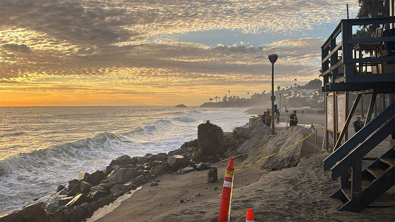
If you’re planning a visit or a move and you’ve seen the photos: yes, several of our beaches look very different right now. Hurricane Marie stayed far offshore. The long south swell it sent, combined with king tides over Labor Day weekend, stripped sand from south-facing beaches across Orange County. In Laguna, Aliso Beach lost most of its sand — rocks and old pier remnants are exposed, and part of the parking lot remains closed. Some South Laguna coves are down to cobble. A seawall and deck failed near Victoria Beach. Four oceanfront homes on Ocean Way were yellow-tagged for yard and seawall damage. Lifeguards made more than 200 rescues over the holiday weekend. The village, the canyons, downtown, and most neighborhoods were not hit. The oceanfront is what changed. Please stay off the steep cut banks and closed sections. Check City of Laguna Beach and Marine Safety updates before you head to Aliso, Victoria, or the south coves. Sand often returns with winter swell, but this summer already ran thin, and another active season is ahead. Laguna is still Laguna. The shoreline is just telling the truth this month. We’ll keep this page updated as conditions and access change.